These records are presented as research aids. The original scan is the controlling source; the transcription preserves uncertainty rather than silently filling gaps.
How to use this page: choose a record below, read the transcription beside the original, and treat the evidence limits seriously. Deed citations and plat citations are kept separate. A deed mentioning Lookout Mountain does not, by itself, prove a cemetery boundary.
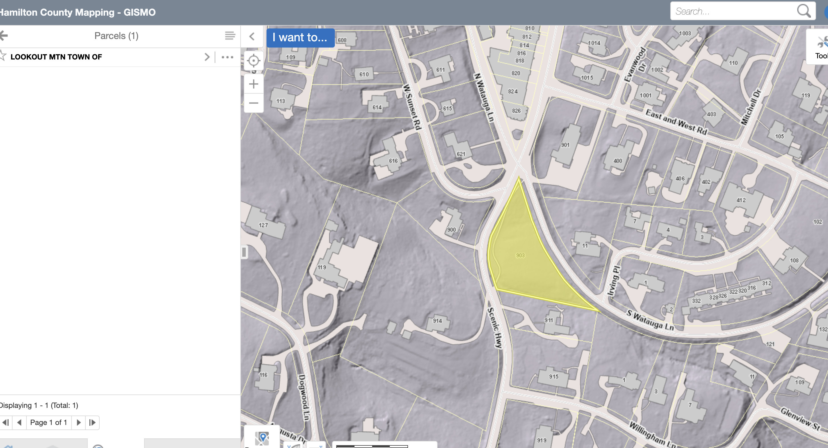
Hamilton County Mapping — GISMO shows a yellow-highlighted parcel between Scenic Hwy and S Watauga Ln. The selected record is labeled “LOOKOUT MTN TOWN OF.”
Source: Hamilton County Mapping — GISMO; screenshot supplied by Rebeca Allred on September 30, 2026. Reproduced without alteration.
This screenshot provides modern parcel context. It does not establish a historic cemetery boundary or the location of individual graves.
Effective Dec. 10, 1971Book 2014, p. 92Original scan: 5 pages
Grace B. Hunt and ten co-owners conveyed land in the Third Civil District, lying between Watauga Lane and Lookout Mountain Scenic Highway, to James A. and Naomi G. Burkart and Edwin P. Sr. and Mary M. Beachum. The deed states: “There is a small area near the Northern end of the above described property, on which there are several graves. This conveyance is made subject to the existance thereof,” after which the recorded copy has words struck through. The deed cites prior title to Book 510, page 8.
Limits: Spelling is as recorded. The deed does not name the cemetery, count the graves, or describe the bounds of the area. The prior-title instrument cited at Book 510, page 8 has not yet been seen.
Archive ID DEED-2214-259 · excerpt transcription
Burkart and Beachum to the Town of Lookout Mountain
James A. and Naomi G. Burkart and Edwin P. Beachum Sr. gave the land described in the 1971 deed to the Town of Lookout Mountain. The gift is made “SUBJECT TO the area near the Northern end of the premises, on which are located graves, and the rights of maintenance thereof, with right of access thereto.” The Hamilton County Assessor lists this instrument as the current deed for parcel 166M C 008, 903 Scenic Highway, owned by the Town of Lookout Mountain.
Limits: The deed does not name the cemetery, say whose graves these are, or fix the bounds of the area. It shows that graves were known on this land in 1971 and 1974. It is not a legal cemetery boundary.
Archive ID DEED-R-113 · partial transcription
Alexander and Levina Hunt convey an interest in Lookout Mountain land
Executed Jan. 31, 1885Book R, Vol. 2, p. 113 → Book 44, p. 113Original scan: 2 pages
The instrument conveys Alexander Hunt’s interest in a larger Lookout Mountain tract to W. R. King, H. Clay Evans, D. Woodworth Jr., H. F. Temple, and W. S. Marshall. It refers to Sections 17–20, the Tennessee–Georgia line, the Rogers-to-Chandler deed, and a road leading from Sunset Rock toward the Natural Bridge House.
Limits: Handwriting is faint in portions of the legal description. This is a working transcription of legible text, not a certified copy.
Archive ID DEED-T-5-578 · partial transcription
Lookout Mountain Company to Henry Stix, trustee
Executed Dec. 21, 1894Filed Jan. 2, 1895Book T, Vol. 5, p. 578 → Book 124, p. 578Original scan: 4 pages
The Lookout Mountain Company conveyed to Henry Stix, as trustee for himself, Adolph S. Ochs, George W. Ochs, and James Gottschalk, an undivided five-eighths interest in a 108-acre tract bounded on the south by the Georgia state line, together with twenty-seven lots in the company’s Subdivisions No. 1 and No. 2. The deed identifies the 108 acres as the property Mrs. H. L. Whiteside conveyed to the company on March 3, 1887. Title-interest recitals from this instrument were later cited in the 1915–1916 cemetery litigation.
Limits: Lot numbers that cannot be read safely have not been filled in. The deed does not mention a burial ground.
Archive ID DEED-262-336 · fuller transcription
John T. and Josephine Speight to Isaac Moore
Executed Oct. 25, 1911Recorded Book 262, pp. 336–337Original scan: 2 pages
John T. Speight conveyed Isaac Moore the south 270 feet by 110 feet of two adjoining pieces of Lookout Mountain property. The description begins near Goddard’s Spring and the old road. This deed is a candidate tract for mapping, but the deed itself does not identify the cemetery.
Limits: Punctuation and line breaks are lightly normalized for web reading. The deed identifies a tract and its parent instruments, not a cemetery boundary.
Archive ID DEED-M-3-306 · full transcription
Anderson and Louisa Bryant to the Chattanooga & Lookout Mountain Railway Company
Executed Aug. 13, 1888Book M, Vol. 3, p. 306 → Book 65, p. 306Original scan: 2 pages
Anderson Bryant, signing by mark, conveyed a fifty-foot right of way through “the lands now occupied by me as a home place on the top of Lookout Mountain,” three acres more or less, bought from Sallie Morbit on Aug. 19, 1878. Louisa Bryant released dower and homestead. A sketch in the deed book labels the strip “7/10 Acre.”
Limits: The home-place description follows a spring, hollows, and neighbors’ lines without distances. The deed does not mention a burial ground.
Archive ID DEED-262-26 · full transcription
Anderson and Carrie Bryant to D. T. Clippinger
Executed Oct. 3, 1911Book B, Vol. 11, p. 26 → Book 262, p. 26Original scan: 2 pages
For $3,500, Anderson Bryant sold a parcel bounded on the east by the west line of the county Boulevard and on the west by the east line of the railroad right of way, between a stone culvert on a branch and a rock culvert in a hollow on the Alex Hunt line. Carrie Bryant joined to release dower and homestead. Both signed by mark.
Limits: No bearings or distances. The deed does not mention a burial ground, and its position relative to the cemetery has not been established.
Archive ID DEED-276-228 · full transcription
Anderson Bryant and A. E. Love to Trustees, A.M.E. Zion Church
Executed Sept. 5, 1912Book P, Vol. 11, p. 228 → Book 276, p. 228Original scan: 2 pages
For one dollar, Anderson Bryant and A. E. Love conveyed to themselves and Lizzie Dumas, as trustees of the African Methodist Episcopal Zion Church in America, the west 43 feet of Lots 1–3, Block 4, Lookout Mountain Company’s Addition No. 2, fronting Ellen Street. Carrie Bryant and Georgia Love also signed.
Limits: A platted church lot with no burial language. The location of Ellen Street has not been established. This deed is not evidence about the cemetery.
Archive status: This is the first release. Additional deed scans will be added as their originals are matched, transcribed, and checked. Plat citations remain separate from deed citations.